Due to the efforts to build a border wall or other similar infrastructure in the Big Bend region, this post is highly political. If all you want is to see the pictures, scroll and don’t read.
At the conclusion of my December 2025 trip, I didn’t know when I would be back or if I would get to visit the Basin again. After all, the Lodge reconstruction project was set to begin and was expected to take several years to complete, during which time the Basin would be closed to vehicular traffic. Well, that project was cancelled shortly before it was set to begin. This is probably just as well. Given how much Trump and Republicans in general hate our public lands, I had no confidence that it would have been finished, and instead the Basin would just have sat closed until sometime during the next decade. Maybe. It’s going to take a long time to clean up the mess.
Early in 2026, news broke that the federal government was moving forward with plans for physical walls throughout the Big Bend region. An early map showed physical walls into Big Bend Ranch State Park, and “smart wall” technology from there through the rest of the State Park, the National Park, and Black Gap Wildlife Management Area and beyond. The physical wall might have, for instance, cut off public access to the Hoodoos Trail.

In the months since, things have gone back and forth, and it is hard to know what the plans are from one day to the next. Given that this administration is full of inveterate liars, I don’t trust anything they say, when they say it. When they say something, they prevaricate. At times, we have seen that they plan to build a full wall in at least a portion of the national park, or that they would construct paved roads over mountains in some of the most remote areas of the entire border. Apparently, the US government has never heard of this new invention called the Jeep.
Any of this work would ruin the darkest skies in at least CONUS, if not the entire country.
The best place to find more information is at the Big Bend Sentinel, which has been the main source for local coverage.
Getting out there again before some portion of the area is destroyed became a high priority. With Independence Day having fallen on a weekend this year, the trip became possible. A five-day trip (two travel days plus three actual days) only needed two days of PTO, rather than three.
Outside of Alpine (over an hour from the park entrance), there are few traditional hotels or motels in the region. Airbnb and Vrbo are the two largest collections of lodging in the area.
I’d known about Longhorn Ranch Motel for as long as I’d been visiting the region as an adult. Under its old owners, it had no web presence, and so it just never rose to the top when I was looking for places to stay. A couple of years ago or so, that changed. I’d considered it during our first (mostly) full family trip in 2025, but went with another option. This year, we chose that. The rate was very good, and the room actually holds 4 people.
Travel Day
If you ask most people who live in the southern part of Texas what route you should take to Big Bend, you will be told US-90. Although IH-10 is scenic in areas, US-90 has a lot more scenery, particularly west of Del Rio. US-90 has the iconic crossing of the Pecos River.

There are a lot of things along this route, and you could easily stretch it to two days. Maybe sometime.
Since the motel is far away from anything, we had dinner first and then went to the motel. We got there not long before sunset. After we got settled, I took what I think is one of the best pics I’ve ever taken.

You are generally looking south at the foothills of the Christmas Mountains. Summer is the monsoon, and the desert after a rain is a treat. Not only might you get great views of thunderstorms like this, but the creosotebush becomes fragrant, a smell that can’t really be described but must be experienced, and the ocotillos, which normally look dead, turn green.
The wall is very unpopular in the region. Throughout the greater region, and especially in Study Butte-Terlingua, there were signs with various anti-wall slogans, including “#stopthesteel” and “Don’t Tread on Big Bend” emblazoned on a Gadsden Flag.
I saw these fliers posted at the Starlight.


We got too late a start to take part in the Independence Day protest, but we did wave as we drove past.
This is, by the way, not the first time in the current Congressional session that Abbott has refused to call a timely special election to fill a seat. He previously left a majority Democratic seat vacant in Houston for over a year. Tony Gonzales is a Republican, but Abbott must expect this seat to be taken by a Democrat, and so he is disenfranchising Texans to maintain the GOP’s tiny margin in Congress.
I hope to see the entire length of the border turn blue this November.
Day 1
At the motel
I’m a generally impatient photography editor and often forget to use masks to gain control over areas of a picture. I made it a point to use masks, where appropriate, on this trip.
Before we got underway for the day, I walked around the motel and took some pics. A couple were usable.


River Road to Pinto Canyon
Farm-to-Market Road 170, known as the River Road (not to be confused with the primitive road of the same name in the national park), is generally considered one of the most scenic drives in the state, if not the whole country. I have driven it on almost every trip. The most scenic part, between Lajitas and Presidio, is at times mere feet from the border.
I’ve never seen anyone cross here.
The eastern half or so of the most scenic stretch is inside Big Bend Ranch State Park. As mentioned earlier, at various times, portions of this park have been shown as having a physical wall. What are the current plans? Who knows. If anyone does, they won’t tell the American people.
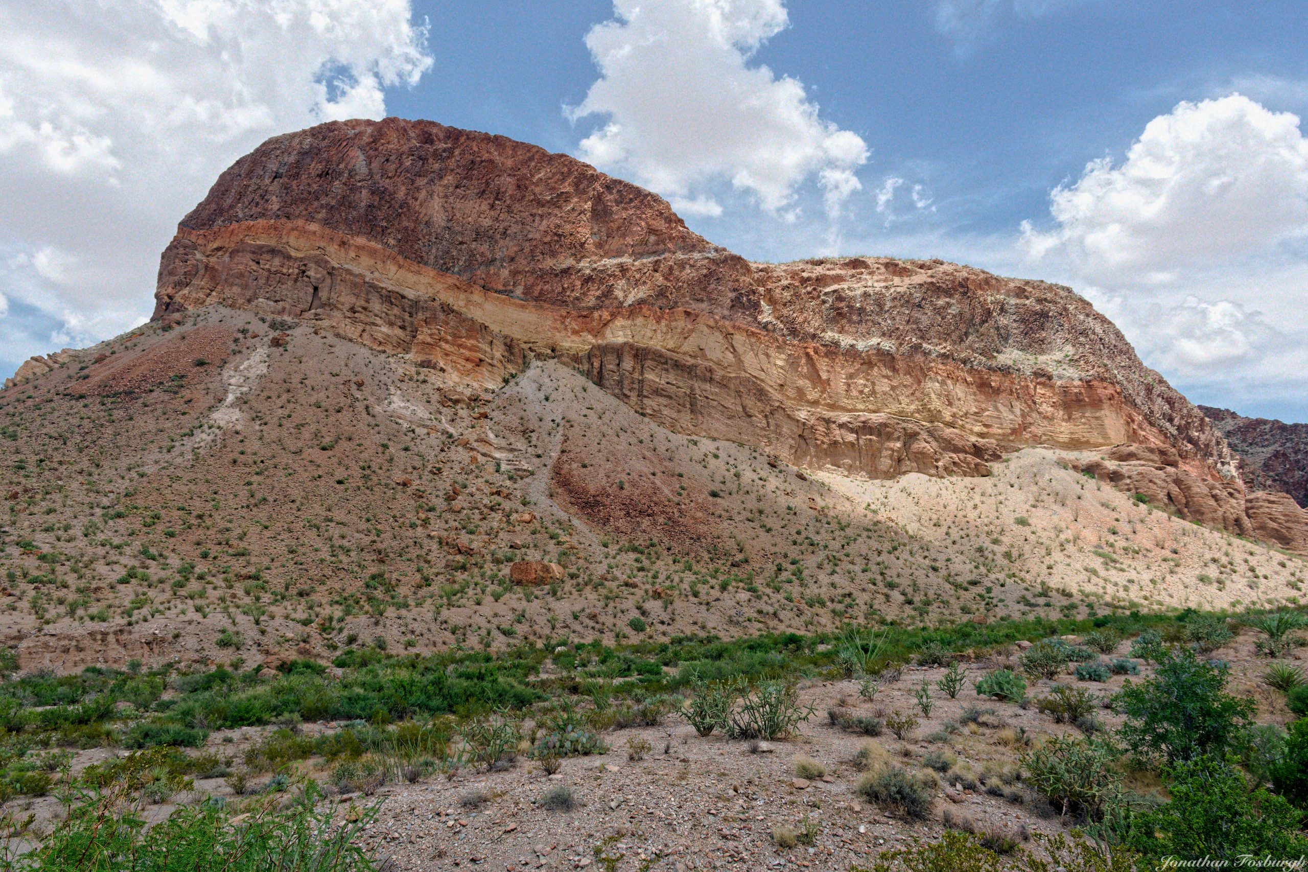
This was potentially our last time to make this drive with the scenery unmarred by a monument to conservative racism and xenophobia. I hadn’t specifically planned to make any stops, but I made a last-second decision to stop at the Hoodoos trailhead. A hoodoo is a type of erosional remnant where a relatively more resilient type of rock “holds up” the softer rock under it. They are relatively common in southwestern North America, especially in Utah. There are a number throughout the Big Bend region, though none that I know of are as spectacular as the ones in, say, Bryce Canyon.
Building a wall here would at least cut off the ability of American citizens to visit one of our natural wonders, if not outright destroy them. We know that previous wall construction efforts have wantonly destroyed nature.


The main part of River Road ends in Presidio. But the highway continues to the northwest another 50 or so miles. This might be one of the least-trafficked highways in Texas, and the road condition shows it. There are a handful of small settlements along the road. One of them, Ruidosa, serves as the southern end of Pinto Canyon Road, an improved dirt road that ascends Pinto Canyon through the Chinati Mountains.
Like many of the mountains of Texas, the Chinatis are volcanic; in this case, the remains of some overlapping calderas. A portion of the range is being preserved as Chinati Mountains State Natural Area; as of 2026, there is no general public access. It is expected to open in 2032.
I didn’t make any stops on this trip up the canyon, but I did make some on my first trip back in 2024. This picture gives you a good idea of the type of scenery you get as you start to enter the lower parts of the mountains.

Pinto Canyon Road is generally passable from north to south in 2WD, but south to north comes close to requiring at least AWD as you exit the top of the canyon. My Jeep lost traction in a couple of brief sections of that final climb, but I didn’t have to engage 4WD.
Skyline Drive, Davis Mountains State Park
I can’t stress how vast the distances out here are, and how much time you have to allocate to get anywhere. The stretch of River Road from Lajitas to Presidio isn’t even 60 miles, but it takes well over an hour to drive without stopping anywhere; it is a very windy and hilly road, with a very steep grade in one section as you ascend and then descend a laccolith. After finishing Pinto Canyon, we opted to head straight to Fort Davis, and specifically to Davis Mountains State Park. The park is on the periphery of the core area of the Davis Mountains, another volcanic range. I haven’t had an opportunity to hike the state park yet; the main thing I do there is make the drive up Skyline Drive, which has great views of the surrounding mountains. The Davis Mountains are a major source of summer thunderstorms, and I frequently get good pics of storms from Skyline Drive. This time was no different.

One of the most well-known features of the state park is the Indian Lodge, a hotel built by the CCC back in the 1930s. Skyline Drive offers a good view of the lodge.

Day 2
The East and Southeast Side of Big Bend National Park
We began the day by driving to almost the furthest point you reach via paved road: Hot Springs Historic District. The spring itself is at the end of a generally well-maintained dirt road, though the drive is not for the faint of heart, nor for those with wide (duallies) or especially long vehicles due to the road clinging to the cliffs, one way each side, with a ravine in the middle. In general, the southeast part of the park is the hottest region (with Rio Grande Village often being the hottest place in the US during the May-June timeframe), and the (short) hike to the spring is entirely exposed. Even if you are just going to walk down to the old bathhouse and back to your car, you should really take water, even in the winter.
As it was, the old bathhouse was almost impossible to find, even having been there many times. The river was high; it was generally filled in with mud, and more overgrown than I even remember seeing it. We barely saw one wall.


The canyon the spring sits in has some interesting strata.


From the hot springs, we made our way up through the east side of the park to the Dagger Flat Auto Trail. My understanding is that this was once supposed to be a road that was generally accessible to passenger cars. I wouldn’t. On a previous trip, I actually came across someone who drove the whole road in a Mustang. It’s certainly not the worst road in the park, but it is still rough in spots, and you have to drive through a couple of stretches of dry wash; these would be impassable after a rain.
Along with Old Ore Road, Dagger Flat Auto Trail is the only road that leads into the Sierra del Caballo Muerto (albeit the northern foothills); the road to Rio Grande Village does, however, skirt the edge at the range’s southern extent.
Dagger Flat Auto Trail is an out-and-back road that leads to Dagger Flat, an area that contains a forest of Giant Dagger yuccas. The best time to drive this road is in the spring, when the yuccas are in bloom. The second best time is whenever you’re able to.


The Basin
At some point between Dagger Flat and the Basin, I bumped a setting on my camera, a fact which I didn’t realize until the next day. This setting caused me to take pictures in very high ISO and very high shutter speeds. The shutter speed probably wasn’t a huge problem; the high ISO was. High ISO frequently causes a lot of noise, which can be hard to work with. While we were in the Basin, we were typically under cloud cover, but the distance still had bright skies with bright clouds. I had to underexpose my subjects to prevent unusably overexposed skies. Underexposing exacerbates the noise issue at high ISO. I have so far only been able to get one picture to work from this time in the Basin: Casa Grande. I may try again with some of my others.

We also made the drive to Grapevine Hills, where the Balanced Rock trailhead is. That road is normally accessible to passenger vehicles, except after rain. Driving beyond that trailhead (to some backcountry campsites) requires high clearance and could require 4WD at times. We made no stops on this drive, so I didn’t take any pictures.
Day Three
Ross Maxwell Scenic Drive
The Ross Maxwell Scenic Drive, named for the park’s first superintendent, geologist Ross Maxwell, runs on the west side of the park from the main East/West Road to Castolon, with an extension to Santa Elena Canyon. That is, the road goes there when it isn’t closed due to flooding. Roads in the desert flood easily with what seems to be trivial amounts of rain, but monsoon rains fall hard, and arid landscapes don’t absorb water very well.
Ross Maxwell would no doubt be rolling over in his grave at the thought of a border wall of any kind.
The road to Santa Elena was closed.
Normally, I would do the trip to Santa Elena by either driving down Ross Maxwell and coming back via the unpaved Old Maverick, or down Old Maverick and back by way of Ross Maxwell. However, Old Maverick was also closed due to recent rains, so we went down to Castolon and then made stops on the way back.
I pretty much always go for an analog look to my pics, generally selecting color profiles that emulate film, and I generally always add grain. When I want to go for a very analog look, I run my pics through Dehancer. I used Dehancer for the pics of the old equipment at Castolon.


I also took a picture of the south face of Cerro Castellan while we were at Castolon. Cerro Castellan is a major landmark in this region of the park.

There is a pullout on Ross Maxwell that is on the west face of Cerro Castellan. There are some good views of the many volcanic features in this part of the park there.


The second of these two images shows a lot of tuff, a type of rock formed from hardened volcanic ash. A lot more tuff is visible a little to the north at Tuff Canyon. It was here that I finally realized I had bumped a setting and fixed my ISO and shutter speed issue.


Next up is Mule Ears.
I’ve done the hike once before. It doesn’t take you to the Mule Ears (eroded volcanic dikes), but around one side and behind, descending into Smoky Creek, whence you can hike to the Dodson Trail.
I did that hike on a dreary, overcast winter day and made some terrible technical errors in my photography. I need to do it again in better conditions and with the knowledge I have since gained.
Atmospheric haze and brilliant sunshine frequently make getting good pics of the Mule Ears from the overlook difficult.

The next stop is Burro Mesa. The south face of Burro Mesa contains Burro Mesa Pouroff. A pouroff is a name given to a normally dry waterfall. The Burro Mesa Pouroff has two trails: one along the top of the mesa to the top of the pouroff, and one to the base of the mesa via the wash the pouroff feeds when it is running. I have done the lower pouroff hike once, a very long time ago. The upper trail remains on my to-do list, as does the nearby hike to Burro Spring.
The south face of the mesa has some spectacular geology.


I probably walked about a quarter to a half of the trail to take pictures this time. Like most desert trails, it’s exposed, and I wasn’t dressed for hiking, nor did I have water on me.


The final stop on our trip north on Ross Maxwell was Sam Nail Ranch. The site still has a working windmill and, along with Dugout Wells, is one of the most reliable sources of water in the desert areas of the park. Like Dugout Wells, it’s an oasis and is a good place for spotting wildlife; birds and insects, if nothing else.

Little remains of the ranch. These pics were run through Dehancer to give them an old look.


In addition to the working windmill, there used to be a ruined one. It has toppled over and now lies in a pile next to the trail. It made an appearance in one of the best pics I’ve ever taken.

Paint Gap Road
The final activity of the trip was driving Paint Gap Road. The road passes some old ranching facilities, through a gap in the Paint Hills, and ends at the remains of more ranch facilities. Until you get to the gap (just after the PG2 campsite), the road is generally passable to most vehicles. This time, however, it was not. Due to a patch of mud just before PG2, for the first time ever, I had to use 4WD in Big Bend.
Beyond PG2, high clearance is always necessary. I know this because I once did this road in a vehicle that didn’t have true high clearance, and I was treated to rocks scraping the undercarriage. This is not a problem in a Jeep.
As I mentioned, the road ends at the ruins of one of the old ranches that used to exist in what is now the national park. I know this sounds like a broken record at this point, but, owing to lighting conditions and haze, I was only able to use one pic I took at the end of Paint Gap.

End of Trip
After dinner, it was time to head back to the motel. The trip got a great bookend, as I was able to take a picture of a thunderstorm over the Christmas Mountains, as I had on the first night.

The drive is long, taking 10-12 hours when accounting for gas and food stops. The trip home never starts as early as the trip out; why return to reality any earlier than necessary? I’m not getting any younger, so it is rare to make any unnecessary stops on the way home.
With luck, I’ll return soon. It is the rare person indeed who visits the Bend and doesn’t leave a portion of their heart behind.
Hopefully, that next trip will still feature views unmarred by a monument to the racism and xenophobia of a very loud minority of this country.